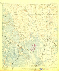
1895 Map of Panasoffkee
USGS Topo · Published 1903About this map
Lake Panasoffkee and the surrounding wetlands of the Withlacoochee River system dominate this late-19th-century landscape. The map illustrates a transitional period where established water-bound settlements like Rutland and Carlson met the burgeoning rail corridor to the east. The Florida Central and Peninsular RR serves as a backbone for growth, linking early citrus and timber communities such as Wildwood, Oxford, and Coleman.
Find a feature on this map
29 named features on this map. Tap any name to fly to it.
Don’t see what you’re looking for? This feature index may not catch every label — zoom into the map to look around manually.
Map Details
Editions of this 1895 Panasoffkee Map
5 editions found
Other maps of this area

1892 · Dunnellon
USGS Topo · 1:62,500

1893 · Panasoffkee
USGS Topo · 1:62,500

1894 · Dunnellon
USGS Topo · 1:62,500

1895 · Tsala Apopka
USGS Topo · 1:62,500

1895 · Panasoffkee
USGS Topo · 1:62,500

1895 · Ocala
USGS Topo · 1:62,500

1954 · Nobleton
USGS Topo · 1:24,000

1954 · Tsala Apopka NE
USGS Topo · 1:24,000

1954 · Inverness
USGS Topo · 1:24,000

1954 · Dunnellon SE
USGS Topo · 1:24,000