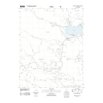
2011 Map of Panguitch Lake
USGS Topo · Published 2011About this map
Panguitch Lake dominates the northeastern landscape of this 2011 survey, serving as the central hub for local recreation and hydrology. The area is characterized by a high-altitude network of lodges and camps, including Deer Trail Lodge, Beaver Dam Lodge, and the Panguitch Lake Resort. Below the Panguitch Lake Dam, the terrain transitions into a complex system of valleys and mountains, notably Blue Spring Mountain and Prince Mountain.
Find a feature on this map
49 named features on this map. Tap any name to fly to it.
Don’t see what you’re looking for? This feature index may not catch every label — zoom into the map to look around manually.
Map Details
Editions of this 2011 Panguitch Lake Map
This is the sole edition of this map. No revisions or reprints were ever made.
Other maps of this area

1886 · Kanab
USGS Topo · 1:250,000

1953 · Cedar City
USGS Topo · 1:250,000

1958 · Cedar City
USGS Topo · 1:250,000

1958 · Cedar Breaks
USGS Topo · 1:62,500

1958 · Panguitch Lake
USGS Topo · 1:62,500

1962 · Cedar City
USGS Topo · 1:250,000

1971 · Fivemile Ridge
USGS Topo · 1:24,000

1971 · Parowan
USGS Topo · 1:24,000
1971 · Red Creek Reservoir
USGS Topo · 1:24,000

1980 · Panguitch
USGS Topo · 1:100,000