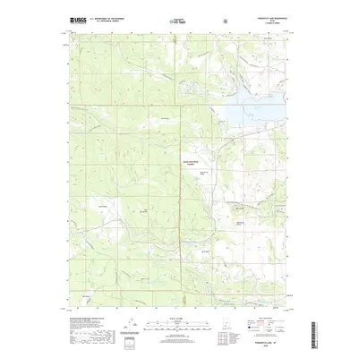
2020 Map of Panguitch Lake
USGS Topo · Published 2020About this map
Panguitch Lake dominates the northeastern corner of this landscape, serving as a focal point for the surrounding Dixie National Forest. Situated on the high Markagunt Plateau, the area is defined by a network of high-elevation valleys and volcanic features. Large basins like Blue Spring Valley, Castle Valley, and Dry Valley sit between prominent heights such as Prince Mtn and Miller Knoll.
Find a feature on this map
54 named features on this map. Tap any name to fly to it.
Don’t see what you’re looking for? This feature index may not catch every label — zoom into the map to look around manually.
Map Details
Editions of this 2020 Panguitch Lake Map
This is the sole edition of this map. No revisions or reprints were ever made.
Other maps of this area

1886 · Kanab
USGS Topo · 1:250,000

1953 · Cedar City
USGS Topo · 1:250,000

1958 · Cedar City
USGS Topo · 1:250,000

1958 · Cedar Breaks
USGS Topo · 1:62,500

1958 · Panguitch Lake
USGS Topo · 1:62,500

1962 · Cedar City
USGS Topo · 1:250,000

1971 · Fivemile Ridge
USGS Topo · 1:24,000

1971 · Parowan
USGS Topo · 1:24,000
1971 · Red Creek Reservoir
USGS Topo · 1:24,000

1980 · Panguitch
USGS Topo · 1:100,000