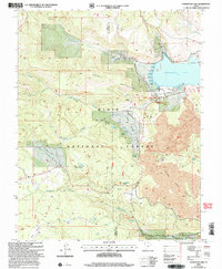
2002 Map of Panguitch Lake
USGS Topo · Published 2005About this map
Panguitch Lake dominates the northeastern corner of this high-altitude landscape, where the waters are managed at Panguitch Lake North and Panguitch Lake South. This 2002 revision of the terrain within the Dixie National Forest reveals a complex network of seasonal drainages and permanent springs that define life in the high country. The boundary between Iron and Garfield counties bisects the map, crossing over Prince Mountain and down toward the headwaters of Mammoth Creek.
Find a feature on this map
35 named features on this map. Tap any name to fly to it.
Don’t see what you’re looking for? This feature index may not catch every label — zoom into the map to look around manually.
Map Details
Editions of this 2002 Panguitch Lake Map
This is the sole edition of this map. No revisions or reprints were ever made.
Other maps of this area

1886 · Kanab
USGS Topo · 1:250,000

1953 · Cedar City
USGS Topo · 1:250,000

1958 · Cedar City
USGS Topo · 1:250,000

1958 · Cedar Breaks
USGS Topo · 1:62,500

1958 · Panguitch Lake
USGS Topo · 1:62,500

1962 · Cedar City
USGS Topo · 1:250,000

1971 · Fivemile Ridge
USGS Topo · 1:24,000

1971 · Parowan
USGS Topo · 1:24,000
1971 · Red Creek Reservoir
USGS Topo · 1:24,000

1980 · Panguitch
USGS Topo · 1:100,000