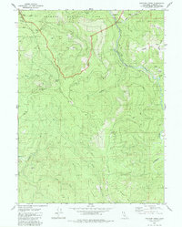
1982 Map of Panther Creek
USGS Topo · Published 1982About this map
Redwood National Park dominates the northern reaches of this coastal Humboldt County terrain, protecting a landscape defined by sharp ridges and drainages that feed the Little River. The topography is marked by named high points and corridors like Shotgun Pass and Devils Pass, while several prairie openings—Barber Prairie, Johnson Prairie, and Indian Prairie—break the dense forest cover along the eastern heights near Arbor Camp Ridge. Evidence of resource management and early infrastructure is scattered throughout, including a Gaging Station on Coyote Creek and various Gravel Pit locations tucked into the hillsides. The network of unnamed four-wheel-drive roads and tracks marked private highlights the complex land use at the park's edge during the early 1980s, as the region balanced conservation with local industry and remote homesteading along Panther Creek and Wiregrass Ridge.
Find a feature on this map
24 named features on this map. Tap any name to fly to it.
Don’t see what you’re looking for? This feature index may not catch every label — zoom into the map to look around manually.
Map Details
Editions of this 1982 Panther Creek Map
This is the sole edition of this map. No revisions or reprints were ever made.
Other maps of this area

1922 · Eureka
USGS Topo · 1:62,500

1922 · Korbel
USGS Topo · 1:62,500

1925 · Hoopa
USGS Topo · 1:125,000

1933 · Eureka
USGS Topo · 1:48,000

1942 · Eureka
USGS Topo · 1:62,500

1945 · Trinidad
USGS Topo · 1:62,500

1945 · Coyote Peak
USGS Topo · 1:62,500

1945 · Blue Lake
USGS Topo · 1:62,500

1948 · Weed
USGS Topo · 1:250,000

1949 · Eureka
USGS Topo · 1:250,000