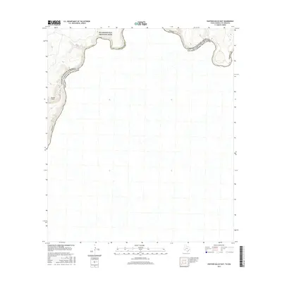
2016 Map of Panther Gulch East
USGS Topo · Published 2016About this map
Rio Grande Wild and Scenic River defines the northern boundary of this territory, where the water carved a deep path through the West Texas desert. The river serves as the international border, separating the United States of America and Estados Unidos Mexicanos. This 2016 survey documents a sparsely populated landscape where natural drainage patterns and elevation changes dominate the geography. Significant topographical features like Panther Gulch are noted near the western edge of the map, illustrating the arid, dissected terrain typical of the Big Bend region. The map also delineates the junction of Brewster Co and Terrell Co, providing a clear record of administrative boundaries in this remote river corridor.
Find a feature on this map
7 named features on this map. Tap any name to fly to it.
Don’t see what you’re looking for? This feature index may not catch every label — zoom into the map to look around manually.
Map Details
Editions of this 2016 Panther Gulch East Map
This is the sole edition of this map. No revisions or reprints were ever made.
Other maps of this area

1918 · Dryden Crossing
USGS Topo · 1:62,500

1918 · Indian Wells
USGS Topo · 1:62,500

1959 · Emory Peak
USGS Topo · 1:250,000

1965 · Emory Peak
USGS Topo · 1:250,000
1983 · Panther Gulch East
USGS Topo · 1:24,000
1983 · Panther Gulch West
USGS Topo · 1:24,000
1983 · Candilla Canyon West
USGS Topo · 1:24,000
1983 · Taylor Canyon
USGS Topo · 1:24,000
1983 · Candilla Canyon East
USGS Topo · 1:24,000
1983 · McClain Canyon
USGS Topo · 1:24,000