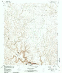
1983 Map of Candilla Canyon East
USGS Topo · Published 1984About this map
The Rio Grande Rio Bravo carves a deep, winding path along the international border between Texas and Coahuila in this 1983 survey. This arid landscape is defined by its complex drainage systems, where the meandering San Francisco Creek and the steep-walled Isinglass Canyon converge near the river's edge. The map captures the geopolitical boundary established by the Treaty of 1970, showing the United States of America and Estados Unidos Mexicanos divided by the river’s centerline. Inland, the terrain is marked by an Indefinite Boundary and the meeting point of the Terrell Co and Brewster Co lines. Human presence is sparse, indicated only by a remote Landing Strip in the northeast and occasional livestock infrastructure like a solitary Well and Tank. The intricate contouring reveals the erosional patterns of Washboard Canyon and Seminole Canyon, illustrating the stark geology of the Trans-Pecos region.
Find a feature on this map
12 named features on this map. Tap any name to fly to it.
Don’t see what you’re looking for? This feature index may not catch every label — zoom into the map to look around manually.
Map Details
Editions of this 1983 Candilla Canyon East Map
This is the sole edition of this map. No revisions or reprints were ever made.
Other maps of this area

1918 · Dryden Crossing
USGS Topo · 1:62,500

1918 · Indian Wells
USGS Topo · 1:62,500

1928 · Sanderson
USGS Topo · 1:125,000

1954 · Fort Stockton
USGS Topo · 1:250,000

1958 · Fort Stockton
USGS Topo · 1:250,000

1959 · Emory Peak
USGS Topo · 1:250,000

1965 · Emory Peak
USGS Topo · 1:250,000

1969 · Sanderson SE
USGS Topo · 1:24,000

1969 · Mofeta
USGS Topo · 1:24,000
1969 · Hagler Canyon
USGS Topo · 1:24,000