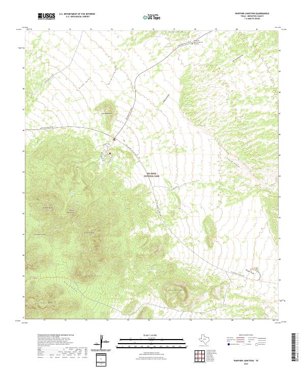
2022 Map of Panther Junction
USGS Topo · Published 2022About this map
Big Bend National Park serves as the expansive backdrop for this topographic study, centered on the high-desert terrain where the Chisos Mountains rise above the surrounding flats. The landscape is defined by massive formations such as Pummel Peak, Panther Peak, and Nugent Mtn, punctuated by vital water sources like Quail Spring and Rock Spring. Human presence is marked by the central hub at Panther Junction and the remote Nina Marie Seawell Hannold Gravesite near Hannold Hill. A network of thoroughfares, including the Rio Grande Village Road and Persimmon Gap Road, provides access to the primitive beauty of Pine Canyon and the natural passages of Smugglers Gap, reflecting the delicate balance between park infrastructure and the preserved wilderness.
Find a feature on this map
33 named features on this map. Tap any name to fly to it.
Don’t see what you’re looking for? This feature index may not catch every label — zoom into the map to look around manually.
Map Details
Editions of this 2022 Panther Junction Map
This is the sole edition of this map. No revisions or reprints were ever made.
Other maps of this area

1903 · Chisos Mountains
USGS Topo · 1:125,000

1905 · Chisos Mountains
USGS Topo · 1:125,000

1959 · Emory Peak
USGS Topo · 1:250,000

1965 · Emory Peak
USGS Topo · 1:250,000

1971 · Glenn Spring
USGS Topo · 1:24,000
1971 · McKinney Springs
USGS Topo · 1:24,000
1971 · Grapevine Hills
USGS Topo · 1:24,000
1971 · San Vicente
USGS Topo · 1:24,000
1971 · Emory Peak
USGS Topo · 1:24,000
1971 · Sombrero Peak
USGS Topo · 1:24,000