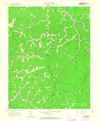
1963 Map of Panther
USGS Topo · Published 1965About this map
Tug Fork and the Norfolk and Western railway corridor define the rugged social and economic geography of this borderland between West Virginia and Virginia. In the early 1960s, the settlement of Panther serves as a focal point for the region's extractive industry, evidenced by numerous mines, a tipple, and a strip mine visible on the high ridges. The landscape is heavily marked by family genealogy, with a dense network of small burial grounds such as Robertson Cem, Lockhart Cem, and Mullins Cem dotting the hollows of the Sandy River Forest. Educational and spiritual life is anchored by local landmarks like the Trace Fork Sch and Little Zion Ch. The intricate topography of the Panther Ridge area is navigated via a system of deep-cut drainage branches, including Meredith Branch and Trap Fork, reflecting the isolated, hollow-based settlement patterns characteristic of the Appalachian coalfields.
Find a feature on this map
108 named features on this map. Tap any name to fly to it.
Don’t see what you’re looking for? This feature index may not catch every label — zoom into the map to look around manually.
Map Details
Editions of this 1963 Panther Map
3 editions found
Other maps of this area

1886 · Grundy
USGS Topo · 1:125,000

1887 · Warfield
USGS Topo · 1:125,000

1890 · Grundy
USGS Topo · 1:125,000

1891 · Tazewell
USGS Topo · 1:125,000

1891 · Oceana
USGS Topo · 1:125,000

1891 · Warfield
USGS Topo · 1:125,000

1892 · Grundy
USGS Topo · 1:125,000

1893 · Oceana
USGS Topo · 1:125,000

1895 · Tazewell
USGS Topo · 1:125,000

1897 · Tazewell
USGS Topo · 1:125,000