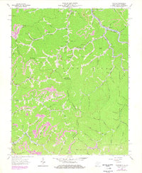
1963 Map of Panther
USGS Topo · Published 1978About this map
Tug Fork and the Norfolk and Western railway corridor define the rugged northern edge of this West Virginia and Virginia borderland. The topography is dominated by the steep dissection of Sandy River Ridge, where a network of narrow hollows and creeks like Longpole Cr and Bull Creek support isolated family settlements and mountain industries. The landscape is marked by the prominence of the coal economy, evidenced by numerous strip mines and localized mines that punctuate the high ridges. Deep within the winding valleys, community life is anchored by traditional institutions such as Little Zion Ch, Greenbrier Fork Ch, and rural schools like McKinley Sch. The map reveals a high density of family burial grounds, including the Blankenship Cem and Justice Cem, providing a detailed record of the generational residency patterns in the State Forest region during the mid-20th century.
Find a feature on this map
112 named features on this map. Tap any name to fly to it.
Don’t see what you’re looking for? This feature index may not catch every label — zoom into the map to look around manually.
Map Details
Editions of this 1963 Panther Map
3 editions found
Other maps of this area

1886 · Grundy
USGS Topo · 1:125,000

1887 · Warfield
USGS Topo · 1:125,000

1890 · Grundy
USGS Topo · 1:125,000

1891 · Tazewell
USGS Topo · 1:125,000

1891 · Oceana
USGS Topo · 1:125,000

1891 · Warfield
USGS Topo · 1:125,000

1892 · Grundy
USGS Topo · 1:125,000

1893 · Oceana
USGS Topo · 1:125,000

1895 · Tazewell
USGS Topo · 1:125,000

1897 · Tazewell
USGS Topo · 1:125,000