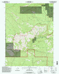
1995 Map of Panther Spring
USGS Topo · Published 1998About this map
Ishi Wilderness and the Tehama Wildlife Area dominate this section of the northern Sierra foothills, revealing a landscape defined by deep canyons and high volcanic plateaus. The map documents early land use through named ranching sites and family homesteads such as Peligreen Place, Avery Place, and Pape Place. These locations, alongside Wild Horse Corral and Stone Corral, suggest a history of seasonal grazing and movement across the ridges. Water sources are critical here, with numerous labeled points like Tail Holt Spring and Two Barrel Spring providing relief across Indian Ridge and Horseback Ridge. The drainage patterns of North Fork Antelope Creek and Boat Gunwale Creek illustrate the challenging geography that historically limited settlement to specific flats and crossings like Cedar Crossing.
Find a feature on this map
43 named features on this map. Tap any name to fly to it.
Don’t see what you’re looking for? This feature index may not catch every label — zoom into the map to look around manually.
Map Details
Editions of this 1995 Panther Spring Map
This is the sole edition of this map. No revisions or reprints were ever made.
Other maps of this area

1886 · Lassen Peak
USGS Topo · 1:250,000

1892 · Lassen Peak
USGS Topo · 1:250,000

1894 · Lassen Peak
USGS Topo · 1:250,000

1935 · Paynes Creek
USGS Topo · 1:96,000

1941 · Mineral
USGS Topo · 1:125,000
1953 · Panther Spring
USGS Topo · 1:62,500

1955 · Westwood
USGS Topo · 1:250,000

1956 · Lassen Peak
USGS Topo · 1:62,500

1956 · Manton
USGS Topo · 1:62,500

1958 · Westwood
USGS Topo · 1:250,000