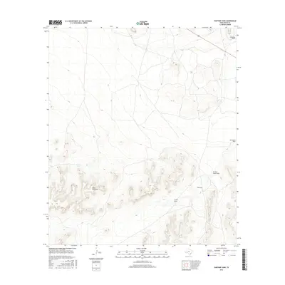
2016 Map of Panther Tank
USGS Topo · Published 2016About this map
Glass Mountains dominate the southwestern portion of this West Texas landscape, providing significant relief in an otherwise arid expanse. The terrain is defined by a series of drainages and seasonal water features that dictate the movement of ranching operations and travelers through this part of Pecos County. Notable among these are Nineteen Draw and Monument Draw, which cut through the landscape towards the northeast. The presence of Panther Tank serves as a critical point of interest, marking a localized water source essential for livestock in this high-desert environment. Further south, the map details the complex drainage patterns of Burnen Tower Draw, Cox Draw, and Carlos Draw, illustrating the natural conduits that manage the region's infrequent but heavy rainfall. This map effectively documents the geographic relationship between the highland mountain spurs and the lower desert draws that characterize the modern ranching territory.
Find a feature on this map
7 named features on this map. Tap any name to fly to it.
Don’t see what you’re looking for? This feature index may not catch every label — zoom into the map to look around manually.
Map Details
Editions of this 2016 Panther Tank Map
This is the sole edition of this map. No revisions or reprints were ever made.
Other maps of this area

1920 · Longfellow
USGS Topo · 1:125,000

1923 · Sierra Madera
USGS Topo · 1:62,500

1928 · Comanche Spring
USGS Topo · 1:125,000

1954 · Fort Stockton
USGS Topo · 1:250,000

1958 · Fort Stockton
USGS Topo · 1:250,000

1968 · Busher Canyon
USGS Topo · 1:24,000

1968 · Ebers Camp
USGS Topo · 1:24,000
1968 · Reininger Draw
USGS Topo · 1:24,000

1973 · Fort Stockton
USGS Topo · 1:250,000
1980 · Sierra Madera SE
USGS Topo · 1:24,000