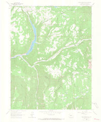
1964 Map of Paonia Reservoir
USGS Topo · Published 1967About this map
Paonia Reservoir serves as the focal point of this mid-1960s survey, marking the confluence where Muddy Creek and Anthracite Creek meet to form the North Fork Gunnison River. The landscape is dominated by the high-elevation terrain of the Gunnison National Forest, featuring prominent landforms like Marcellina Mountain and the expansive Snowshoe Mesa. This era shows a transition in land use, where rugged mountain trails and early jeep tracks connect isolated outposts like the Snowshoe Cabin and the Anthracite Creek Guard Station.
Find a feature on this map
52 named features on this map. Tap any name to fly to it.
Don’t see what you’re looking for? This feature index may not catch every label — zoom into the map to look around manually.
Map Details
Editions of this 1964 Paonia Reservoir Map
4 editions found
Other maps of this area

1888 · Anthracite
USGS Topo · 1:62,500

1889 · Anthracite
USGS Topo · 1:62,500

1893 · Anthracite
USGS Topo · 1:62,500

1894 · Anthracite
USGS Topo · 1:62,500

1938 · Mt. Gunnison
USGS Topo · 1:48,000

1945 · Mount Gunnison
USGS Topo · 1:62,500

1956 · Montrose
USGS Topo · 1:250,000

1957 · Leadville
USGS Topo · 1:250,000

1959 · Leadville
USGS Topo · 1:250,000

1959 · Montrose
USGS Topo · 1:250,000