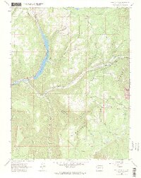
1964 Map of Paonia Reservoir
USGS Topo · Published 1984About this map
Paonia Reservoir dominates the valley floor in this 1964 snapshot of the Gunnison National Forest. Fed by Muddy Creek and the North Fork Gunnison River, the reservoir is a central water management feature surrounded by high mesas and deep drainages. Human activity in the area is marked by seasonal and agricultural outposts such as the Anthracite Creek Guard Station and Hotchkiss Ranch, alongside recreational spots like Erickson Springs.
Find a feature on this map
38 named features on this map. Tap any name to fly to it.
Don’t see what you’re looking for? This feature index may not catch every label — zoom into the map to look around manually.
Map Details
Editions of this 1964 Paonia Reservoir Map
4 editions found
Other maps of this area

1888 · Anthracite
USGS Topo · 1:62,500

1889 · Anthracite
USGS Topo · 1:62,500

1893 · Anthracite
USGS Topo · 1:62,500

1894 · Anthracite
USGS Topo · 1:62,500

1938 · Mt. Gunnison
USGS Topo · 1:48,000

1945 · Mount Gunnison
USGS Topo · 1:62,500

1956 · Montrose
USGS Topo · 1:250,000

1957 · Leadville
USGS Topo · 1:250,000

1959 · Leadville
USGS Topo · 1:250,000

1959 · Montrose
USGS Topo · 1:250,000