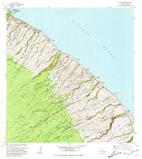
1980 Map of Papaaloa
USGS Topo · Published 1981About this map
Laupahoehoe Pt juts into the Pacific Ocean, anchoring a coastline marked by numerous homestead divisions and the steep gulches of the Hamakua Coast. This 1980 revision, based on surveys dating back to the 1950s, reflects a landscape transitioning from historical plantation-era settlement to contemporary use. Significant local landmarks include the Tidal Wave Memorial at Laupahoehoe County Park and the Laupahoehoe Sch, alongside industrial sites like Cinder Pits and various quarries. The interior is dominated by the Hilo Forest Reserve, where deep ravines carved by the Maulua Stream and Umauma Stream drop toward the sea. The map also identifies the Honohina (Site) and older residential clusters such as Kapehu Camp, providing a record of habitation patterns between the North Hilo District and South Hilo District.
Find a feature on this map
76 named features on this map. Tap any name to fly to it.
Don’t see what you’re looking for? This feature index may not catch every label — zoom into the map to look around manually.
Map Details
Editions of this 1980 Papaaloa Map
2 editions found
Other maps of this area

1915 · Hamakua
USGS Topo · 1:62,500

1915 · Honomu
USGS Topo · 1:62,500

1954 · Hawaii North
USGS Topo · 1:250,000

1956 · Pua Akala
USGS Topo · 1:24,000

1956 · Keanakolu
USGS Topo · 1:24,000

1957 · Kukaiau
USGS Topo · 1:24,000

1959 · Hawaii North
USGS Topo · 1:250,000

1961 · Hawaii North
USGS Topo · 1:250,000
1966 · Akaka Falls
USGS Topo · 1:24,000
1966 · Papaikou
USGS Topo · 1:24,000