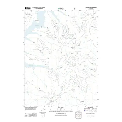
2012 Map of Papoose Creek
USGS Topo · Published 2012About this map
Trinity Lake dominates the northwestern portion of this 2012 survey, its shoreline defining the drainage patterns of the surrounding highlands. The rugged geography is marked by significant geologic features like Comstock Slide and the prominent heights of Trinity Mountain and Bowerman Ridge. A complex network of United States Forest Service roads, including 34n04 and 35n30, provides access to these elevations and to the Captains Point Campground situated near the water's edge.
Find a feature on this map
67 named features on this map. Tap any name to fly to it.
Don’t see what you’re looking for? This feature index may not catch every label — zoom into the map to look around manually.
Map Details
Editions of this 2012 Papoose Creek Map
This is the sole edition of this map. No revisions or reprints were ever made.
Other maps of this area

1890 · Red Bluff
USGS Topo · 1:250,000

1894 · Red Bluff
USGS Topo · 1:250,000

1913 · Weaverville
USGS Topo · 1:125,000

1944 · French Gulch
USGS Topo · 1:62,500

1948 · French Gulch
USGS Topo · 1:62,500

1950 · Minersville
USGS Topo · 1:62,500

1950 · Schell Mtn
USGS Topo · 1:62,500

1950 · Weaverville
USGS Topo · 1:62,500
1952 · Schell Mtn.
USGS Topo · 1:62,500

1952 · Weaverville
USGS Topo · 1:62,500