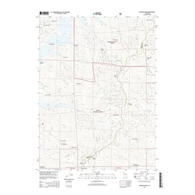
2015 Map of Papoose Creek
USGS Topo · Published 2015About this map
Trinity Lake dominates the northwest corner of this terrain, its convoluted shoreline tucked between the high crests of the Trinity Mountains. This landscape is defined by its complex drainage network, where the Papoose Creek system and its many forks—including the N Fork Papoose Cr, E Fork Papoose Cr, and S Fork Papoose Cr—carve through deep gulches and steep ridges. The map reveals a wild geography of named features like Comstock Slide and Crystal Spring, while the boundary between the Shasta National Forest and Trinity National Forest follows the high ground of the Trinity and Shasta County line. Geologists and local historians can trace the intricate network of gulches, from Feeny Gulch to Eastman Gulch, that feed into the larger reservoirs and river systems of Northern California.
Find a feature on this map
41 named features on this map. Tap any name to fly to it.
Don’t see what you’re looking for? This feature index may not catch every label — zoom into the map to look around manually.
Map Details
Editions of this 2015 Papoose Creek Map
This is the sole edition of this map. No revisions or reprints were ever made.
Other maps of this area

1890 · Red Bluff
USGS Topo · 1:250,000

1894 · Red Bluff
USGS Topo · 1:250,000

1913 · Weaverville
USGS Topo · 1:125,000

1944 · French Gulch
USGS Topo · 1:62,500

1948 · French Gulch
USGS Topo · 1:62,500

1950 · Minersville
USGS Topo · 1:62,500

1950 · Schell Mtn
USGS Topo · 1:62,500

1950 · Weaverville
USGS Topo · 1:62,500
1952 · Schell Mtn.
USGS Topo · 1:62,500

1952 · Weaverville
USGS Topo · 1:62,500