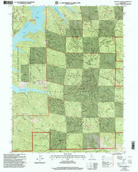
1998 Map of Papoose Creek
USGS Topo · Published 2003About this map
Trinity Mountains peaks and the sprawling waters of the Whiskeytown-Shasta-Trinity National Recreation Area dominate this 1998 revision. The map documents the intricate shoreline of Trinity Lake, specifically the Van Ness Arm and Papoose Arm, which provide critical boat access at Captains Point Campground Boat Access. This landscape is defined by its drainage systems, where numerous gulches like Digger Gulch and Eastman Gulch carve through the ridges toward the central reservoir.
Find a feature on this map
43 named features on this map. Tap any name to fly to it.
Don’t see what you’re looking for? This feature index may not catch every label — zoom into the map to look around manually.
Map Details
Editions of this 1998 Papoose Creek Map
This is the sole edition of this map. No revisions or reprints were ever made.
Other maps of this area

1890 · Red Bluff
USGS Topo · 1:250,000

1894 · Red Bluff
USGS Topo · 1:250,000

1913 · Weaverville
USGS Topo · 1:125,000

1944 · French Gulch
USGS Topo · 1:62,500

1948 · French Gulch
USGS Topo · 1:62,500

1950 · Minersville
USGS Topo · 1:62,500

1950 · Schell Mtn
USGS Topo · 1:62,500

1950 · Weaverville
USGS Topo · 1:62,500
1952 · Schell Mtn.
USGS Topo · 1:62,500

1952 · Weaverville
USGS Topo · 1:62,500