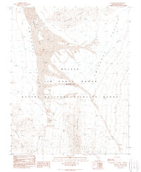
1989 Map of Papoose Lake
USGS Topo · Published 1989About this map
Papoose Lake dominates the high desert landscape of this late-twentieth-century topographical survey, sitting at the heart of the Nellis Air Force Range (Restricted Area). The map details a strictly controlled environment where military activity and conservation overlap, as the southern portion of the quadrangle is occupied by the Desert National Wildlife Range. The terrain is characterized by the broad, dry expanse of Emigrant Valley, flanked by the peaks of the Papoose Range to the north and the Burled Hills and Half Pint Range to the south. This provisional edition, based on 1968 aerial photography and updated in 1989, provides an intricate look at the natural drainages like Nye Canyon that feed the seasonal dry lake bed, illustrating the isolated geography of Lincoln County.
Find a feature on this map
8 named features on this map. Tap any name to fly to it.
Don’t see what you’re looking for? This feature index may not catch every label — zoom into the map to look around manually.
Map Details
Editions of this 1989 Papoose Lake Map
This is the sole edition of this map. No revisions or reprints were ever made.
Other maps of this area

1907 · Las Vegas
USGS Topo · 1:250,000

1908 · Las Vegas
USGS Topo · 1:250,000

1942 · Emigrant Valley
USGS Topo · 1:125,000

1942 · Indian Spring
USGS Topo · 1:125,000

1952 · Papoose Lake
USGS Topo · 1:62,500
1952 · Frenchman Lake
USGS Topo · 1:62,500

1954 · Caliente
USGS Topo · 1:250,000

1954 · Las Vegas
USGS Topo · 1:250,000

1957 · Las Vegas
USGS Topo · 1:250,000

1959 · Caliente
USGS Topo · 1:250,000