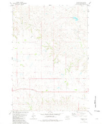
1981 Map of Parade
USGS Topo · Published 1981About this map
Parade serves as a central hub for this portion of the Cheyenne River Indian Reservation, situated along Highway 212 in the early 1980s. The landscape is defined by the drainage of Goose Creek, which flows southeast toward the Goose Creek Dam. This survey documents a transition in local transportation, noting an Abandoned railroad grade that runs parallel to the highway through the southern portion of the quadrangle. Agricultural operations are anchored by the Strong Ranch and Ridgeview Ranch, while smaller features like a local Cem and several water Well sites indicate the dispersed nature of settlement in this part of Dewey County. Precise elevations are maintained through several benchmarks, including Parade BM 2393 and BM 2417 located near the townsite.
Find a feature on this map
17 named features on this map. Tap any name to fly to it.
Don’t see what you’re looking for? This feature index may not catch every label — zoom into the map to look around manually.
Map Details
Editions of this 1981 Parade Map
This is the sole edition of this map. No revisions or reprints were ever made.
Other maps of this area

1951 · Ridgeview NW
USGS Topo · 1:24,000

1952 · Parade NE
USGS Topo · 1:24,000

1952 · Parade NW
USGS Topo · 1:24,000

1953 · McIntosh
USGS Topo · 1:250,000

1954 · Pierre
USGS Topo · 1:250,000

1958 · Pierre
USGS Topo · 1:250,000

1958 · McIntosh
USGS Topo · 1:250,000

1981 · Herbert Creek
USGS Topo · 1:24,000

1981 · Rousseau Creek NW
USGS Topo · 1:24,000

1981 · Herbert Creek NE
USGS Topo · 1:24,000