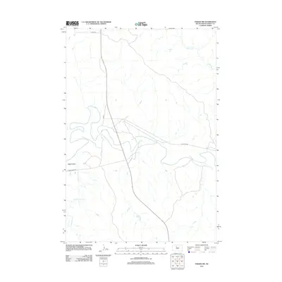
2012 Map of Parade NW
USGS Topo · Published 2012About this map
Green Grass stands as the primary settlement in this northern South Dakota landscape, situated near the confluence of the Moreau River and Green Grass Cr. The area is characterized by a network of rural routes and watercourses, with the meandering path of the Moreau River carving through the center of the terrain. Local travel in the early 21st century relied on roads such as On The Tree Rd and Green Grass Rd, which provide access to the dispersed homesteads and grazing lands. To the northeast, the drainage of Redwater Cr feeds into the larger river system, reflecting the essential role of these waterways in the region's ranching economy. The grid of section lines and county designations like Co Hwy-5h shows the intersection of natural topography and organized land management in Dewey County.
Find a feature on this map
8 named features on this map. Tap any name to fly to it.
Don’t see what you’re looking for? This feature index may not catch every label — zoom into the map to look around manually.
Map Details
Editions of this 2012 Parade NW Map
This is the sole edition of this map. No revisions or reprints were ever made.
Other maps of this area

1952 · Parade NE
USGS Topo · 1:24,000

1952 · Lantry NE
USGS Topo · 1:24,000

1952 · Parade NW
USGS Topo · 1:24,000

1953 · McIntosh
USGS Topo · 1:250,000

1958 · McIntosh
USGS Topo · 1:250,000

1978 · Peach Lake
USGS Topo · 1:24,000

1978 · Little Moreau Lake
USGS Topo · 1:24,000

1978 · Livermant Lake
USGS Topo · 1:24,000

1981 · Parade SW
USGS Topo · 1:24,000
1981 · Parade
USGS Topo · 1:24,000