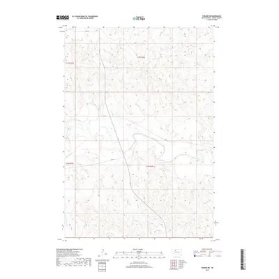
2017 Map of Parade NW
USGS Topo · Published 2017About this map
The Moreau River meanders across this northern South Dakota landscape, carving a wide valley through the rolling hills of Dewey County. This survey captures a rural expanse defined by its watercourses and a sparse network of section-line roads, such as Co Rd 2 and Bia Rd 14. The hydrology of the region is further detailed by the presence of Green Grass Cr in the southwest and Redwater Cr to the northeast, indicating the essential drainage patterns that have shaped the local topography. This 2017 study illustrates the enduring spatial organization of the Public Land Survey System, with township and range lines like t15n r24e and t14n r23e framing the open country between established local routes.
Find a feature on this map
10 named features on this map. Tap any name to fly to it.
Don’t see what you’re looking for? This feature index may not catch every label — zoom into the map to look around manually.
Map Details
Editions of this 2017 Parade NW Map
This is the sole edition of this map. No revisions or reprints were ever made.
Other maps of this area

1952 · Parade NE
USGS Topo · 1:24,000

1952 · Lantry NE
USGS Topo · 1:24,000

1952 · Parade NW
USGS Topo · 1:24,000

1953 · McIntosh
USGS Topo · 1:250,000

1958 · McIntosh
USGS Topo · 1:250,000

1978 · Peach Lake
USGS Topo · 1:24,000

1978 · Little Moreau Lake
USGS Topo · 1:24,000

1978 · Livermant Lake
USGS Topo · 1:24,000

1981 · Parade SW
USGS Topo · 1:24,000
1981 · Parade
USGS Topo · 1:24,000