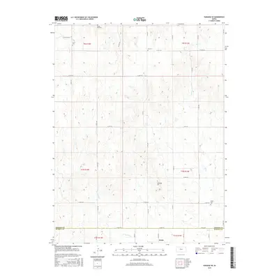
2015 Map of Paradise NE
USGS Topo · Published 2015About this map
The settlement of Waldo sits at the southern edge of this Central Kansas landscape, marking the transition between the agricultural uplands and the drainage of the Wolf Cr basin. This area on the Osborne Co Russell Co line is defined by a series of small rural burial grounds that speak to the early homesteading history of the region, including Victor Cem, Cole Cem, and Cedar Bluff Cem in the north, and Grand Center Cem further south. The terrain is characterized by the prominent elevation of Tabletop Hill, which rises above the surrounding sections. A network of section-line roads, such as Co RD 671 and S 190th Ave, provides access to the scattered farmsteads and agricultural plots that dominate the landscape, while the meandering W Fork Wolf Cr carves its path through the southern sections of the survey.
Find a feature on this map
72 named features on this map. Tap any name to fly to it.
Don’t see what you’re looking for? This feature index may not catch every label — zoom into the map to look around manually.
Map Details
Editions of this 2015 Paradise NE Map
This is the sole edition of this map. No revisions or reprints were ever made.
Other maps of this area

1896 · Osborne
USGS Topo · 1:125,000

1955 · Beloit
USGS Topo · 1:250,000

1959 · Beloit
USGS Topo · 1:250,000

1978 · Osborne SW
USGS Topo · 1:24,000
1978 · Paradise NW
USGS Topo · 1:24,000
1978 · Paradise
USGS Topo · 1:24,000
1978 · Alton SW
USGS Topo · 1:24,000
1978 · Luray
USGS Topo · 1:24,000
1978 · Vincent
USGS Topo · 1:24,000
1978 · Waldo
USGS Topo · 1:24,000