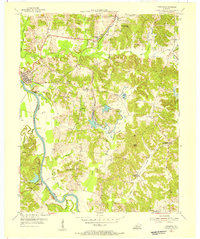
1954 Map of Paradise
USGS Topo · Published 1955About this map
The Green River serves as the dividing line between Muhlenberg and Ohio Counties in this mid-century portrait of western Kentucky's coal and river country. Along its banks, the Airdrie Iron Furnace stands as a landmark of earlier industrial efforts, located near the small riverside community of Paradise. The landscape is a complex mix of traditional rural life and heavy industry, where numerous Strip Mine operations are carved into the hillsides alongside family landmarks like Maddox Cem and Williams Cem.
Find a feature on this map
39 named features on this map. Tap any name to fly to it.
Don’t see what you’re looking for? This feature index may not catch every label — zoom into the map to look around manually.
Map Details
Editions of this 1954 Paradise Map
This is the sole edition of this map. No revisions or reprints were ever made.
Other maps of this area

1909 · Hartford
USGS Topo · 1:62,500

1909 · Central City
USGS Topo · 1:62,500

1911 · Drakesboro
USGS Topo · 1:48,000

1911 · Dunmor
USGS Topo · 1:48,000

1913 · Drakesboro
USGS Topo · 1:62,500

1914 · Dunmor
USGS Topo · 1:62,500

1952 · Equality
USGS Topo · 1:24,000

1953 · Drakesboro
USGS Topo · 1:24,000

1953 · Central City East
USGS Topo · 1:24,000

1953 · South Hill
USGS Topo · 1:24,000