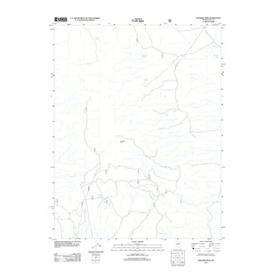
2011 Map of Paradise Peak
USGS Topo · Published 2011About this map
Paradise Peak dominates the high desert terrain of central Nevada in this 2011 survey of northwestern Nye County. The landscape is defined by a critical network of water sources, essential for survival and navigation in this arid region, including Baxter Spring in the north and Coyote Spring in the south. These springs, alongside others like Fifteenmile Spring and Timber Spring, often dictate the placement of local routes and land usage. The map illustrates a sparse but vital transportation network, notably the NFD 075 TRL and various forest service access roads. While modern in its production, the topographic detail reveals the same drainage patterns, such as Antelope Wash, that have shaped this portion of the Great Basin for centuries, providing a clear record of the area's natural landmarks and the named springs that remain its most significant features.
Find a feature on this map
19 named features on this map. Tap any name to fly to it.
Don’t see what you’re looking for? This feature index may not catch every label — zoom into the map to look around manually.
Map Details
Editions of this 2011 Paradise Peak Map
This is the sole edition of this map. No revisions or reprints were ever made.
Other maps of this area

1907 · Tonopah
USGS Topo · 1:250,000

1908 · Tonopah
USGS Topo · 1:250,000

1948 · Paradise Peak
USGS Topo · 1:62,500

1948 · Ione
USGS Topo · 1:62,500

1950 · Paradise Peak
USGS Topo · 1:62,500

1950 · Ione
USGS Topo · 1:62,500

1956 · Tonopah
USGS Topo · 1:250,000

1959 · Tonopah
USGS Topo · 1:250,000

1962 · Tonopah
USGS Topo · 1:250,000
1979 · Goldyke
USGS Topo · 1:24,000