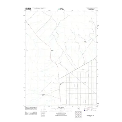
2011 Map of Paradise Well
USGS Topo · Published 2011About this map
Paradise Hill and the surrounding high desert of Humboldt County are documented here during a period of modern rural development. The landscape is defined by the drainage of Tony Creek as it flows toward the valley floor, where a grid of named roads suggests an emerging residential or ranching community. This transition from open terrain to structured lots is evident along Paradise Ranchos Dr and Western Horizon Dr. To the west and east, the natural topography is marked by significant features like Asa Moore Canyon, Long Canyon, and Rocky Canyon, which provide a stark contrast to the surveyed blocks of the settlement area. The central Paradise Well serves as a vital geographic landmark in this arid region, anchoring a network of roads with evocative names such as Godchaux Rd and Flintlock Dr.
Find a feature on this map
26 named features on this map. Tap any name to fly to it.
Don’t see what you’re looking for? This feature index may not catch every label — zoom into the map to look around manually.
Map Details
Editions of this 2011 Paradise Well Map
This is the sole edition of this map. No revisions or reprints were ever made.
Other maps of this area

1882 · Paradise
USGS Topo · 1:250,000

1893 · Paradise
USGS Topo · 1:250,000

1955 · McDermitt
USGS Topo · 1:250,000

1958 · Paradise Valley
USGS Topo · 1:62,500

1958 · Awakening Peak
USGS Topo · 1:62,500

1959 · McDermitt
USGS Topo · 1:250,000

1959 · Bliss
USGS Topo · 1:62,500
1982 · Andorno Ranch
USGS Topo · 1:24,000
1982 · Bloody Run Peak
USGS Topo · 1:24,000
1982 · Mud Spring Canyon
USGS Topo · 1:24,000