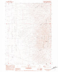
1982 Map of Bloody Run Peak
USGS Topo · Published 1982About this map
Silver State Valley meets the high elevations of the Santa Rosa Range in this 1982 provisional survey of the Nevada desert. The landscape is defined by its water sources, including the historic cattle ranching mark of the Miller and Lux Well and isolated points like Bathtub Spring. Numerous drainages cut through the mountains, notably Bloody Run Canyon and Pinson Canyon, which descend toward the basin floor where Sand Dunes have accumulated. The presence of the China Garden area near the Bloody Run Hills suggests localized zones of past cultivation or habitation within this arid environment. The map provides a detailed view of the terrain around Bloody Run Peak, documenting the sparse road networks and water infrastructure essential for land management and ranching in Humboldt County during the late twentieth century.
Find a feature on this map
17 named features on this map. Tap any name to fly to it.
Don’t see what you’re looking for? This feature index may not catch every label — zoom into the map to look around manually.
Map Details
Editions of this 1982 Bloody Run Peak Map
This is the sole edition of this map. No revisions or reprints were ever made.
Other maps of this area

1882 · Paradise
USGS Topo · 1:250,000

1893 · Paradise
USGS Topo · 1:250,000

1955 · McDermitt
USGS Topo · 1:250,000

1958 · Paradise Valley
USGS Topo · 1:62,500

1958 · Awakening Peak
USGS Topo · 1:62,500

1959 · McDermitt
USGS Topo · 1:250,000

1959 · Bliss
USGS Topo · 1:62,500
1981 · Barrett Springs
USGS Topo · 1:24,000
1982 · Silver State Draw
USGS Topo · 1:24,000
1982 · Awakening Peak
USGS Topo · 1:24,000