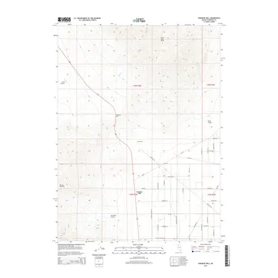
2015 Map of Paradise Well
USGS Topo · Published 2015About this map
Paradise Hill serves as the focal point for this Nevada survey, situated where the high elevations of the Santa Rosa Range meet the desert floor. The landscape is defined by its topographic transition, with the Bloody Run Hills rising to the west and deep cuts like Asa Moore Canyon and Long Canyon channeling seasonal runoff into the flats. Modern habitation is concentrated in the southern portion of the quadrangle, where a grid of rural residential streets including Paradise Ranchos Dr and Cheyenne Dr fans out near Paradise Well. This 2015 data reflects the contemporary footprint of ranching and remote settlement in Humboldt County, showing the intersection of NV-290 and Godchaux Rd as it connects these outposts to the wider region through the high desert terrain.
Find a feature on this map
35 named features on this map. Tap any name to fly to it.
Don’t see what you’re looking for? This feature index may not catch every label — zoom into the map to look around manually.
Map Details
Editions of this 2015 Paradise Well Map
This is the sole edition of this map. No revisions or reprints were ever made.
Other maps of this area

1882 · Paradise
USGS Topo · 1:250,000

1893 · Paradise
USGS Topo · 1:250,000

1955 · McDermitt
USGS Topo · 1:250,000

1958 · Paradise Valley
USGS Topo · 1:62,500

1958 · Awakening Peak
USGS Topo · 1:62,500

1959 · McDermitt
USGS Topo · 1:250,000

1959 · Bliss
USGS Topo · 1:62,500
1982 · Andorno Ranch
USGS Topo · 1:24,000
1982 · Bloody Run Peak
USGS Topo · 1:24,000
1982 · Mud Spring Canyon
USGS Topo · 1:24,000