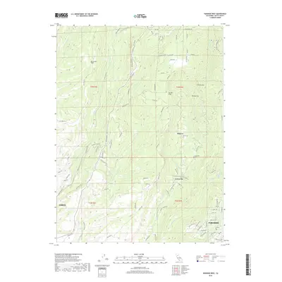
2018 Map of Paradise West
USGS Topo · Published 2018About this map
Big Chico Cr and Little Chico Cr carve deep drainage patterns through the volcanic ridges of Butte County, where the rising Sierra Nevada foothills transition from the valley floor. The landscape is defined by prominent topographical features like Musty Buck Ridge and Doe Mill Ridge, which historically dictated the paths of early transportation routes. Notable among these are the Harris Wagon Rd and Old Chico Canyon Rd, serving as reminders of the era when wagons were the primary means of traversing this steep terrain. The settlements of Centerville and Helltown are clearly marked, providing critical points of reference for local historians and genealogists. These communities are anchored by the Centerville Cem and Nicholl Cem, while smaller landmarks such as Whiskey Flat and Chimney Rock highlight the folk-naming traditions of the region's early residents.
Find a feature on this map
97 named features on this map. Tap any name to fly to it.
Don’t see what you’re looking for? This feature index may not catch every label — zoom into the map to look around manually.
Map Details
Editions of this 2018 Paradise West Map
This is the sole edition of this map. No revisions or reprints were ever made.
Other maps of this area

1891 · Chico
USGS Topo · 1:125,000

1893 · Chico
USGS Topo · 1:125,000

1895 · Chico
USGS Topo · 1:125,000

1912 · Durham
USGS Topo · 1:31,680

1912 · Keefers
USGS Topo · 1:31,680

1912 · Clear Creek
USGS Topo · 1:31,680

1942 · Oroville
USGS Topo · 1:62,500
1944 · Oroville
USGS Topo · 1:62,500

1944 · Richardson Springs
USGS Topo · 1:62,500
1947 · Cherokee
USGS Topo · 1:24,000