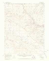
1960 Map of Paradox
USGS Topo · Published 1969About this map
Dolores River carved canyons and uranium-rich mesas define this mid-century western Colorado landscape. The settlement of Paradox sits in its namesake valley, flanked by the Paradox Cem and the La Sal National Forest boundary. A massive concentration of mining claims is visible along the river's bends and the tributary of the San Miguel river, including the Radium Cycle Mine, Golden Cycle Mine, and North Star Mine. The presence of Salt Evaporators near Bedrock and a Salt Well underscores the unique geology of the Saucer Basin and West Paradox Creek drainage. High-altitude landmarks like VABM 7086 Skein on Skein Mesa and the VABM 6339 Wheel on Blue Mesa offer essential navigation points for a terrain marked by deep canyons like Wild Steer Canyon and Hieroglyphic Canyon.
Find a feature on this map
128 named features on this map. Tap any name to fly to it.
Don’t see what you’re looking for? This feature index may not catch every label — zoom into the map to look around manually.
Map Details
Editions of this 1960 Paradox Map
4 editions found
Other maps of this area

1885 · La Sal
USGS Topo · 1:250,000

1916 · Paradox Valley
USGS Topo · 1:125,000

1922 · Paradox Valley
USGS Topo · 1:125,000

1948 · Roc Creek
USGS Topo · 1:24,000

1948 · Bull Canyon
USGS Topo · 1:24,000

1948 · Uravan
USGS Topo · 1:24,000

1948 · Naturita NW
USGS Topo · 1:24,000

1948 · Paradox
USGS Topo · 1:24,000

1949 · Bull Canyon
USGS Topo · 1:24,000

1949 · Davis Mesa
USGS Topo · 1:24,000