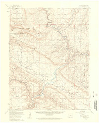
1960 Map of Paradox
USGS Topo · Published 1961About this map
The Dolores River winds through a landscape defined by deep canyons and high mesas in this western Colorado survey. At the center of the valley, the small settlements of Paradox and Bedrock anchor a region shaped by uranium and radium exploration. The topography is a maze of vertical relief, including Carpenter Ridge and the Sewemup Mesa, where complex drainage patterns like Roc Creek and Paradox Creek have carved into the plateau.
Find a feature on this map
99 named features on this map. Tap any name to fly to it.
Don’t see what you’re looking for? This feature index may not catch every label — zoom into the map to look around manually.
Map Details
Editions of this 1960 Paradox Map
4 editions found
Other maps of this area

1885 · La Sal
USGS Topo · 1:250,000

1916 · Paradox Valley
USGS Topo · 1:125,000

1922 · Paradox Valley
USGS Topo · 1:125,000

1948 · Roc Creek
USGS Topo · 1:24,000

1948 · Bull Canyon
USGS Topo · 1:24,000

1948 · Uravan
USGS Topo · 1:24,000

1948 · Naturita NW
USGS Topo · 1:24,000

1948 · Paradox
USGS Topo · 1:24,000

1949 · Bull Canyon
USGS Topo · 1:24,000

1949 · Davis Mesa
USGS Topo · 1:24,000