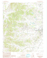
1984 Map of Paragould West
USGS Topo · Published 1993About this map
Crowleys Ridge dominates the western half of this Greene County landscape, creating a distinct topographical rise above the surrounding alluvial plains. The map records the expansion of Paragould toward the west in the early 1980s, documenting a mix of urban growth and agricultural heritage. Transportation corridors are central to the area's development, notably the St Louis Southwestern railroad line and the Municipal Airport near the city center.
Find a feature on this map
14 named features on this map. Tap any name to fly to it.
Don’t see what you’re looking for? This feature index may not catch every label — zoom into the map to look around manually.
Map Details
Editions of this 1984 Paragould West Map
3 editions found
Other maps of this area

1939 · Jonesboro
USGS Topo · 1:62,500

1940 · Gainesville
USGS Topo · 1:62,500

1940 · Marmaduke
USGS Topo · 1:62,500

1941 · Leachville
USGS Topo · 1:62,500

1953 · Memphis
USGS Topo · 1:250,000

1956 · Leachville
USGS Topo · 1:62,500

1956 · Memphis
USGS Topo · 1:250,000

1957 · Poplar Bluff
USGS Topo · 1:250,000

1958 · Jonesboro
USGS Topo · 1:62,500

1958 · Marmaduke
USGS Topo · 1:62,500