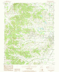
1984 Map of Paragould West
USGS Topo · Published 1984About this map
Paragould serves as the focal point of this Greene County landscape during the early 1980s, showcasing the westward expansion of the city into the surrounding foothills and creek valleys. The layout reveals a transitional period of urban development, where traditional landmarks like the St Louis railroad line and the Municipal Airport meet mid-century leisure features such as the Drive-In Theater and Reynolds Park.
Find a feature on this map
23 named features on this map. Tap any name to fly to it.
Don’t see what you’re looking for? This feature index may not catch every label — zoom into the map to look around manually.
Map Details
Editions of this 1984 Paragould West Map
3 editions found
Other maps of this area

1939 · Jonesboro
USGS Topo · 1:62,500

1940 · Gainesville
USGS Topo · 1:62,500

1940 · Marmaduke
USGS Topo · 1:62,500

1941 · Leachville
USGS Topo · 1:62,500

1953 · Memphis
USGS Topo · 1:250,000

1956 · Leachville
USGS Topo · 1:62,500

1956 · Memphis
USGS Topo · 1:250,000

1957 · Poplar Bluff
USGS Topo · 1:250,000

1958 · Jonesboro
USGS Topo · 1:62,500

1958 · Marmaduke
USGS Topo · 1:62,500