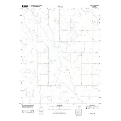
2010 Map of Parallel
USGS Topo · Published 2010About this map
The Canadian River meanders south through this section of Dewey County, carving a wide valley flanked by a network of tributary drainages. The landscape is defined by its rural section-line road system and several family-named burial grounds that speak to the area's early settlement history. The Harrison Cemetery and Little Robe Cemetery are situated north of the river, while the Oakley Cemetery sits near Trail Creek to the west. On the eastern edge of the map, the small community of Sickle is located near the Evergreen Cemetery. Numerous seasonal waterways, including Fiddlers Creek, Squirrel Creek, and Flanders Creek, feed into the river basin from the surrounding plains, illustrating the natural drainage patterns that have long influenced agricultural land use and road placement in this part of western Oklahoma.
Find a feature on this map
26 named features on this map. Tap any name to fly to it.
Don’t see what you’re looking for? This feature index may not catch every label — zoom into the map to look around manually.
Map Details
Editions of this 2010 Parallel Map
This is the sole edition of this map. No revisions or reprints were ever made.
Other maps of this area

1955 · Clinton
USGS Topo · 1:250,000

1955 · Woodward
USGS Topo · 1:250,000

1957 · Clinton
USGS Topo · 1:250,000

1958 · Woodward
USGS Topo · 1:250,000

1962 · Putnam
USGS Topo · 1:62,500

1964 · Oakwood
USGS Topo · 1:62,500

1972 · Hucmac
USGS Topo · 1:24,000

1972 · Canton SW
USGS Topo · 1:24,000
1972 · Taloga
USGS Topo · 1:24,000
1985 · Watonga
USGS Topo · 1:100,000