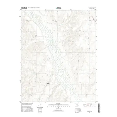
2016 Map of Parallel
USGS Topo · Published 2016About this map
The Canadian River bisects this landscape in Dewey County, shaping the drainage patterns for numerous local tributaries. The small settlement of Parallel sits amidst a grid of section roads, including E0770 Rd and N2340 Rd, which navigate the terrain of the Oklahoma plains. This 2016 survey is particularly valuable for genealogical research, as it identifies several small burial grounds across the quadrant, including Harrison Cem, Little Robe Cem, Oakley Cem, and Evergreen Cem. The geography is defined by the winding paths of several creeks, such as Little Robe Cr, Squirrel Cr, Fiddlers Cr, and One Horse Cr, which flow through the draws and breaks toward the main river channel. The map illustrates how modern county road naming conventions have overlaid the traditional rural landscape, providing a precise spatial reference for family land tracts and historical landmarks.
Find a feature on this map
23 named features on this map. Tap any name to fly to it.
Don’t see what you’re looking for? This feature index may not catch every label — zoom into the map to look around manually.
Map Details
Editions of this 2016 Parallel Map
This is the sole edition of this map. No revisions or reprints were ever made.
Other maps of this area

1955 · Clinton
USGS Topo · 1:250,000

1955 · Woodward
USGS Topo · 1:250,000

1957 · Clinton
USGS Topo · 1:250,000

1958 · Woodward
USGS Topo · 1:250,000

1962 · Putnam
USGS Topo · 1:62,500

1964 · Oakwood
USGS Topo · 1:62,500

1972 · Hucmac
USGS Topo · 1:24,000

1972 · Canton SW
USGS Topo · 1:24,000
1972 · Taloga
USGS Topo · 1:24,000
1985 · Watonga
USGS Topo · 1:100,000