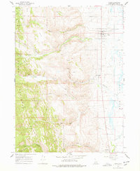
1967 Map of Paris
USGS Topo · Published 1978About this map
Paris and Bloomington sit at the western edge of the Bear Lake Valley, where steep canyons of the Cache National Forest meet the fertile valley floor. This 1967 field survey documents a landscape defined by water management and resource extraction, featuring an early Powerplant on Paris Creek and several mountain mines, including the Boulder Mine and Clark Mine. The transition from the high peaks of Sleight Canyon to the marshes near Bear Lake is bridged by a network of canals and creeks, such as Bloomington Creek and St Charles Creek.
Find a feature on this map
47 named features on this map. Tap any name to fly to it.
Don’t see what you’re looking for? This feature index may not catch every label — zoom into the map to look around manually.
Map Details
Editions of this 1967 Paris Map
3 editions found
Other maps of this area

1909 · Montpelier
USGS Topo · 1:125,000

1911 · Montpelier
USGS Topo · 1:125,000

1915 · Preston
USGS Topo · 1:96,000

1918 · Preston
USGS Topo · 1:125,000

1955 · Preston
USGS Topo · 1:250,000

1958 · Preston
USGS Topo · 1:250,000

1962 · Preston
USGS Topo · 1:250,000

1967 · Montpelier
USGS Topo · 1:24,000

1967 · Paris
USGS Topo · 1:24,000

1967 · Ovid
USGS Topo · 1:24,000