
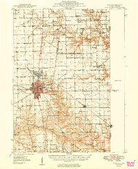
1949 Map of Paris
USGS Topo · Published 1949About this map
Paris serves as the focal point of this late 1940s landscape, where the concentrated urban grid of the county seat meets the expansive agrarian townships of eastern Illinois. The town's industrial and transit foundations are clearly marked by the New York Central Railroad and Pennsylvania Railroad corridors. Just north of the city center, the Twin Lakes and North Arm Twin Lakes provide a recreational contrast to the surrounding productive fields.
Find a feature on this map
83 named features on this map. Tap any name to fly to it.
Don’t see what you’re looking for? This feature index may not catch every label — zoom into the map to look around manually.
Map Details
Editions of this 1949 Paris Map
2 editions found
Other maps of this area

1932 · Marshall
USGS Topo · 1:62,500

1936 · Casey
USGS Topo · 1:48,000

1937 · Marshall
USGS Topo · 1:62,500

1941 · Terre Haute
USGS Topo · 1:24,000

1942 · Dennison
USGS Topo · 1:24,000

1942 · Casey
USGS Topo · 1:62,500

1943 · Casey
USGS Topo · 1:62,500

1946 · Kansas
USGS Topo · 1:62,500

1947 · Ridge Farm
USGS Topo · 1:62,500

1947 · Paris
USGS Topo · 1:62,500