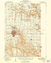
1949 Map of Paris
USGS Topo · Published 1949About this map
Paris serves as the focal point of this 1940s landscape, situated at the junction of the Pennsylvania and New York Central railroads. The town’s transition into the mid-century era is marked by both the Paris Airport and the smaller Midway Landing Field to the north. Outside the city limits, a dense network of over two dozen rural schoolhouses, including Fort Sumter Sch, North Union Sch, and Lanes Branch Sch, illustrates the decentralized nature of local education before the consolidation of rural districts.
Find a feature on this map
87 named features on this map. Tap any name to fly to it.
Don’t see what you’re looking for? This feature index may not catch every label — zoom into the map to look around manually.
Map Details
Editions of this 1949 Paris Map
2 editions found

Other maps of this area

1932 · Marshall
USGS Topo · 1:62,500

1936 · Casey
USGS Topo · 1:48,000

1937 · Marshall
USGS Topo · 1:62,500

1941 · Terre Haute
USGS Topo · 1:24,000

1942 · Dennison
USGS Topo · 1:24,000

1942 · Casey
USGS Topo · 1:62,500

1943 · Casey
USGS Topo · 1:62,500

1946 · Kansas
USGS Topo · 1:62,500

1947 · Ridge Farm
USGS Topo · 1:62,500

1947 · Paris
USGS Topo · 1:62,500