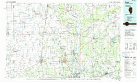
1986 Map of Paris
USGS Topo · Published 1986About this map
The Wabash River and Vermilion River systems dominate this mid-1980s midwestern landscape, carving through the borderlands of Illinois and Indiana. The heavy rail infrastructure of the Baltimore and Ohio RR and Conrail intersects with primary agricultural hubs like Paris, Georgetown, and Chrisman. Cultural and educational landmarks are visible throughout the rural townships, including Georgetown HS and the Bethel Ch and Bethel Cem.
Find a feature on this map
215 named features on this map. Tap any name to fly to it.
Don’t see what you’re looking for? This feature index may not catch every label — zoom into the map to look around manually.
Map Details
Editions of this 1986 Paris Map
2 editions found
Other maps of this area

1899 · Danville
USGS Topo · 1:62,500

1900 · Danville
USGS Topo · 1:62,500

1906 · Urbana
USGS Topo · 1:62,500

1908 · Clay City
USGS Topo · 1:48,000

1910 · Clay City
USGS Topo · 1:62,500

1931 · Fithian
USGS Topo · 1:48,000

1932 · Marshall
USGS Topo · 1:62,500

1933 · Toledo
USGS Topo · 1:62,500

1936 · Oakland
USGS Topo · 1:48,000

1936 · Casey
USGS Topo · 1:48,000