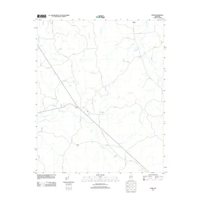
2012 Map of Paris
USGS Topo · Published 2012About this map
The settlement of Paris serves as a central hub for this Lafayette County landscape, where the local road network converges near the banks of Town Cr. The area is defined by an intricate system of waterways, including the winding paths of Otoucalofa Cr and Sarter Cr, which dictate the placement of rural homesteads and agricultural plots. For those tracing family histories, several key burial sites are documented, notably Paris Cem just east of the village and Crocker Cem situated near the headwaters of Dickey Cr. To the north, the small community of Delay sits along the northern edge of the survey, connected by routes like Co RD 434 and Co RD 486. The map captures a quiet, rural moment in northern Mississippi, highlighting the proximity of family-named landmarks such as Drivers Flat Cem to the meandering Smith Cr.
Find a feature on this map
56 named features on this map. Tap any name to fly to it.
Don’t see what you’re looking for? This feature index may not catch every label — zoom into the map to look around manually.
Map Details
Editions of this 2012 Paris Map
This is the sole edition of this map. No revisions or reprints were ever made.
Other maps of this area

1940 · Oxford
USGS Topo · 1:62,500

1942 · Denmark
USGS Topo · 1:62,500

1943 · Denmark
USGS Topo · 1:62,500

1943 · Oxford
USGS Topo · 1:62,500

1954 · Water Valley
USGS Topo · 1:62,500

1955 · Water Valley
USGS Topo · 1:62,500

1956 · Tupelo
USGS Topo · 1:250,000

1958 · Tupelo
USGS Topo · 1:250,000

1972 · Paris
USGS Topo · 1:24,000
1972 · Banner
USGS Topo · 1:24,000