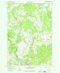
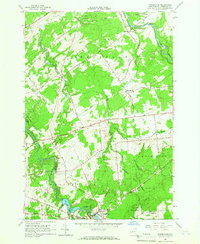
1964 Map of Parishville
USGS Topo · Published 1966This historical map portrays the area of Parishville in 1964, primarily covering St. Lawrence County. Featuring a scale of 1:24000, this map provides a highly detailed snapshot of the terrain, roads, buildings, counties, and historical landmarks in the Parishville region at the time. Published in 1966, it is one of 3 known editions of this map due to revisions or reprints.
Find a feature on this map
51 named features on this map. Tap any name to fly to it.
Don’t see what you’re looking for? This feature index may not catch every label — zoom into the map to look around manually.
Map Details
Editions of this 1964 Parishville Map
3 editions found
Historical Maps of Parishville Through Time
118 maps found

1904 Lisbon
St. Lawrence County, NY

1905 Waddington
St. Lawrence County, NY

1906 Brier Hill
St. Lawrence County, NY

1906 Massena
St. Lawrence County, NY

1906 Red Mills
St. Lawrence County, NY

1907 Massena
St. Lawrence County, NY

1907 Tupper Lake
St. Lawrence County, NY

1908 Potsdam
St. Lawrence County, NY

1910 Canton
St. Lawrence County, NY

1911 Canton
St. Lawrence County, NY

1912 Hammond
St. Lawrence County, NY

1915 Gouverneur
St. Lawrence County, NY

1915 Russell
St. Lawrence County, NY

1916 Oswegatchie
St. Lawrence County, NY

1918 Oswegatchie
St. Lawrence County, NY

1918 Russell
St. Lawrence County, NY

1919 Nicholville
St. Lawrence County, NY

1920 Childwold
St. Lawrence County, NY

1921 Childwold
St. Lawrence County, NY

1921 Nicholville
St. Lawrence County, NY

1921 Stark
St. Lawrence County, NY

1922 Childwold
St. Lawrence County, NY

1923 Stark
St. Lawrence County, NY

1937 Gouverneur
St. Lawrence County, NY

1940 Stark
St. Lawrence County, NY

1942 Barnhart Island
St. Lawrence County, NY

1942 Chase Mills
St. Lawrence County, NY

1942 Long Bow
St. Lawrence County, NY

1942 Massena
St. Lawrence County, NY

1942 Morristown
St. Lawrence County, NY

1942 Murphy Island
St. Lawrence County, NY

1942 Norfolk
St. Lawrence County, NY

1942 Waddington
St. Lawrence County, NY

1943 Barnhart Island
St. Lawrence County, NY

1943 Chase Mills
St. Lawrence County, NY

1943 Colton
St. Lawrence County, NY

1943 Edwardsville
St. Lawrence County, NY

1943 Lisbon
St. Lawrence County, NY

1943 Long Bow
St. Lawrence County, NY

1943 Massena
St. Lawrence County, NY

1943 Morristown
St. Lawrence County, NY

1943 Murphy Island
St. Lawrence County, NY

1943 Norfolk
St. Lawrence County, NY

1943 Ogdensburg East
St. Lawrence County, NY

1943 Ogdensburg West
St. Lawrence County, NY

1943 Parishville
St. Lawrence County, NY

1943 Potsdam
St. Lawrence County, NY

1943 Red Mills
St. Lawrence County, NY

1943 Sparrowhawk Point
St. Lawrence County, NY

1943 Waddington
St. Lawrence County, NY

1944 Canton
St. Lawrence County, NY

1944 Hammond
St. Lawrence County, NY

1946 Louisville
St. Lawrence County, NY

1946 Raquette River
St. Lawrence County, NY

1948 Chippewa Bay
St. Lawrence County, NY

1949 Hammond
St. Lawrence County, NY

1951 Hammond
St. Lawrence County, NY

1951 Harrisville
St. Lawrence County, NY

1951 Natural Dam
St. Lawrence County, NY

1951 Pope Mills
St. Lawrence County, NY

1954 Tupper Lake
St. Lawrence County, NY

1956 Bigelow
St. Lawrence County, NY

1956 Edwards
St. Lawrence County, NY

1956 Gouverneur
St. Lawrence County, NY

1958 Chippewa Bay
St. Lawrence County, NY

1961 Hammond
St. Lawrence County, NY

1961 Natural Dam
St. Lawrence County, NY

1961 Pope Mills
St. Lawrence County, NY

1963 Edwardsville
St. Lawrence County, NY

1963 Lisbon
St. Lawrence County, NY

1963 Morristown
St. Lawrence County, NY

1963 Ogdensburg East
St. Lawrence County, NY

1963 Ogdensburg West
St. Lawrence County, NY

1963 Red Mills
St. Lawrence County, NY

1963 Sparrowhawk Point
St. Lawrence County, NY

1964 Canton
St. Lawrence County, NY

1964 Chase Mills
St. Lawrence County, NY

1964 Colton
St. Lawrence County, NY

1964 Cornwall West
St. Lawrence County, NY

1964 Hogansburg
St. Lawrence County, NY

1964 Louisville
St. Lawrence County, NY

1964 Massena
St. Lawrence County, NY

1964 Morley
St. Lawrence County, NY

1964 Morrisburg
St. Lawrence County, NY

1964 Nicholville
St. Lawrence County, NY

1964 Norfolk
St. Lawrence County, NY

1964 North Lawrence
St. Lawrence County, NY

1964 Parishville
St. Lawrence County, NY

1964 Pierrepont
St. Lawrence County, NY

1964 Potsdam
St. Lawrence County, NY

1964 Rainbow Falls
St. Lawrence County, NY

1964 Raquette River
St. Lawrence County, NY

1964 Sylvan Falls
St. Lawrence County, NY

1964 Waddington
St. Lawrence County, NY

1964 West Potsdam
St. Lawrence County, NY

1966 Fine
St. Lawrence County, NY

1966 Hermon
St. Lawrence County, NY

1966 Oswegatchie SE
St. Lawrence County, NY

1966 Oswegatchie
St. Lawrence County, NY

1968 Childwold
St. Lawrence County, NY

1968 Mount Matumbla
St. Lawrence County, NY

1968 Newton Falls
St. Lawrence County, NY

1968 Stark
St. Lawrence County, NY

1969 Degrasse
St. Lawrence County, NY

1969 Five Ponds
St. Lawrence County, NY

1969 South Edwards
St. Lawrence County, NY

1969 Tooley Pond
St. Lawrence County, NY

1969 West Pierrepont
St. Lawrence County, NY

1970 Albert Marsh
St. Lawrence County, NY

1970 Brother Ponds
St. Lawrence County, NY

1970 Carry Falls Reservoir
St. Lawrence County, NY

1982 Gouverneur
St. Lawrence County, NY

1985 Gouverneur
St. Lawrence County, NY

1985 Tupper Lake
St. Lawrence County, NY

1990 Piercefield
St. Lawrence County, NY

1999 Five Ponds
St. Lawrence County, NY

1999 Newton Falls
St. Lawrence County, NY

1999 Piercefield
St. Lawrence County, NY