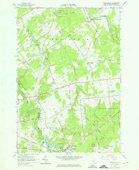
1964 Map of Parishville
USGS Topo · Published 1966About this map
The St Regis River carves through this northern New York landscape, defining the character of St. Lawrence County in the mid-1960s. The settlement of Parishville serves as a primary hub, anchored by the Parishville-Hopkinton Sch and the nearby Fairview Cem. Infrastructure along the West Branch is dominated by the Allen Falls Reservoir and its associated Powerplant, showing the mid-century intersection of natural waterways and hydroelectric utility. Moving north toward Buckton and Beechertown, the terrain transitions into the managed timberlands of St Lawrence State Forest No 31. Smaller crossroads like Southville and Converse appear as tight-knit clusters of rural life, connected by a network of family-named routes such as Hanson Road and Sullivan Road. The map provides a detailed view of these rural communities just before modern developments further altered the pastoral and industrial landscape of the region.
Find a feature on this map
51 named features on this map. Tap any name to fly to it.
Don’t see what you’re looking for? This feature index may not catch every label — zoom into the map to look around manually.
Map Details
Editions of this 1964 Parishville Map
3 editions found
Other maps of this area

1906 · Massena
USGS Topo · 1:62,500

1907 · Massena
USGS Topo · 1:62,500

1908 · Potsdam
USGS Topo · 1:62,500

1915 · Moira
USGS Topo · 1:62,500

1917 · Moira
USGS Topo · 1:62,500

1919 · Nicholville
USGS Topo · 1:62,500

1921 · Nicholville
USGS Topo · 1:62,500

1942 · Long Bow
USGS Topo · 1:24,000

1942 · Norfolk
USGS Topo · 1:24,000

1943 · Potsdam
USGS Topo · 1:31,680