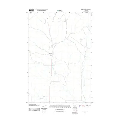
2011 Map of Park Coulee
USGS Topo · Published 2011About this map
Razor Creek and its major tributaries, the West Fork and East Fork, define the drainage patterns of this Yellowstone County landscape. This 2011 survey captures the rural ranching character of the area, centered on the Thirtymile Ranch and the named topographical feature of Park Coulee. The map illustrates a network of essential county roads that provide access across the undulating terrain, including Old Divide Rd, Majerus Rd, and Bedford Rd. These thoroughfares connect isolated homesteads and agricultural operations to the broader region. The lack of dense residential development emphasizes the open-range nature of this portion of Montana, where the geography of the coulees and creek beds dictates the placement of roads and ranch infrastructure.
Find a feature on this map
13 named features on this map. Tap any name to fly to it.
Don’t see what you’re looking for? This feature index may not catch every label — zoom into the map to look around manually.
Map Details
Editions of this 2011 Park Coulee Map
This is the sole edition of this map. No revisions or reprints were ever made.
Other maps of this area

1954 · Roundup
USGS Topo · 1:250,000

1958 · Roundup
USGS Topo · 1:250,000

1979 · Roundup
USGS Topo · 1:100,000

1979 · Harper Coulee
USGS Topo · 1:24,000

1979 · Hay Basin NE
USGS Topo · 1:24,000
1980 · North Fork Crooked Creek East
USGS Topo · 1:24,000

1980 · Dunn Mountain South
USGS Topo · 1:24,000
1980 · Cotton Creek
USGS Topo · 1:24,000

1980 · Dunn Mountain North
USGS Topo · 1:24,000

1980 · Signal Mountain
USGS Topo · 1:24,000