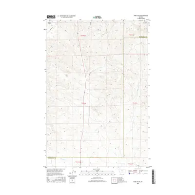
2017 Map of Park Coulee
USGS Topo · Published 2017About this map
The Bull Mountains dominate the northeastern corner of this landscape, where the high-altitude terrain gives way to the drainage systems of Yellowstone Co and Musselshell Co. The area is characterized by deep topographical depressions including Park Coulee and Harper Coulee, which channel seasonal water towards the southern plains. A network of rural connectors, such as Old Divide Rd and Majerus Rd, navigates the complex ridges, following the natural contours of the land. The hydrology is defined by the branching tributaries of Razor Cr, including W Razor Cr and E Fork Razor Cr, which serve as the primary drainage for this transition zone between the high mountains and the lower coulees. This survey captures a rural Montana landscape where section lines and range boundaries, like t5n r26e, organize a terrain shaped by erosion and high-plains water flow.
Find a feature on this map
20 named features on this map. Tap any name to fly to it.
Don’t see what you’re looking for? This feature index may not catch every label — zoom into the map to look around manually.
Map Details
Editions of this 2017 Park Coulee Map
This is the sole edition of this map. No revisions or reprints were ever made.
Other maps of this area

1954 · Roundup
USGS Topo · 1:250,000

1958 · Roundup
USGS Topo · 1:250,000

1979 · Roundup
USGS Topo · 1:100,000

1979 · Harper Coulee
USGS Topo · 1:24,000

1979 · Hay Basin NE
USGS Topo · 1:24,000
1980 · North Fork Crooked Creek East
USGS Topo · 1:24,000

1980 · Dunn Mountain South
USGS Topo · 1:24,000
1980 · Cotton Creek
USGS Topo · 1:24,000

1980 · Dunn Mountain North
USGS Topo · 1:24,000

1980 · Signal Mountain
USGS Topo · 1:24,000