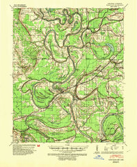
1939 Map of Park Place
USGS Topo · Published 1953About this map
The L’Anguille River and the St Francis River dominate this 1930s landscape, winding through Lee County toward the Mississippi. This survey captures a rural network of tenant farms and local institutions just before significant post-war mechanization and levee expansion. The presence of the Marianna Helena Land Project near Marianna suggests a period of active land resettlement and agricultural planning. The map is exceptionally rich for genealogists, detailing dozens of small rural hubs such as Brickeys, Bledsoe, and Kokomo. Church and school pairings are prominent throughout the region, including Bethlehem Ch & Cem and Antioch Ch & Sch, which served as the primary social anchors for the surrounding hamlets. Transport is defined by the Missouri Pacific Railroad and unique river features like Whiskey Chute and Ball Point, while many family-named features like Spencer Place and Greer Place reflect established local estates.
Find a feature on this map
95 named features on this map. Tap any name to fly to it.
Don’t see what you’re looking for? This feature index may not catch every label — zoom into the map to look around manually.
Map Details
Editions of this 1939 Park Place Map
2 editions found
Other maps of this area

1931 · Horseshoe Lake
USGS Topo · 1:62,500

1939 · Clayton
USGS Topo · 1:62,500

1939 · Horseshoe Lake
USGS Topo · 1:62,500

1939 · Park Place
USGS Topo · 1:62,500

1939 · Wynne
USGS Topo · 1:62,500

1939 · Edmondson
USGS Topo · 1:62,500

1939 · Latour
USGS Topo · 1:62,500

1940 · Marvell
USGS Topo · 1:62,500

1940 · Whitmore
USGS Topo · 1:62,500

1940 · Marianna
USGS Topo · 1:62,500