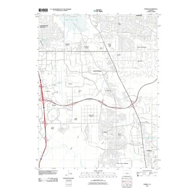
2010 Map of Parker
USGS Topo · Published 2010About this map
Lewis Cemetery and the Aurora Water Well Field sit atop a landscape undergoing rapid suburban transformation southeast of Denver. This area, anchored by Centennial and Parker, shows a transition from historical agricultural infrastructure like the Arapahoe Canal to modern transportation and commercial hubs. The Centennial Airport dominates the central-western portion of the map, surrounded by burgeoning office parks and residential developments like Algonquin Acres and Grand View Estates. Water management is a primary feature of the local geography, evidenced by the large Cherry Creek Lake in the north and several smaller catchments including Inverness Reservoir and the Franktown Parker FPP 1 Reservoir. While the landscape is heavily developed, remnants of earlier industries persist, such as the Madis Mine located near Baldwin Gulch.
Find a feature on this map
72 named features on this map. Tap any name to fly to it.
Don’t see what you’re looking for? This feature index may not catch every label — zoom into the map to look around manually.
Map Details
Editions of this 2010 Parker Map
This is the sole edition of this map. No revisions or reprints were ever made.
Other maps of this area

1890 · East Denver
USGS Topo · 1:125,000

1894 · Castle Rock
USGS Topo · 1:125,000

1913 · Castle Rock
USGS Topo · 1:125,000

1935 · East Denver Nos. 3 and 4
USGS Topo · 1:48,000

1939 · Coal Creek
USGS Topo · 1:24,000

1939 · Elizabeth
USGS Topo · 1:62,500

1940 · Englewood
USGS Topo · 1:31,680

1940 · Piney Creek
USGS Topo · 1:24,000

1940 · Castle Rock
USGS Topo · 1:62,500

1941 · Fitzsimons
USGS Topo · 1:31,680