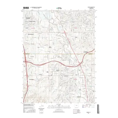
2016 Map of Parker
USGS Topo · Published 2016About this map
Cherry Creek and Cottonwood Creek flow through this heavily developed corridor south of the Denver metro area. The map shows the dense residential and commercial expansion characterizing the mid-2010s, with suburban centers like Stonegate, Lone Tree, and Parker tightly clustered. Higher education is represented by campuses for Arapahoe Community College and the Rocky Vista University College of Osteopathic Medicine. Central to the region's transportation and commerce is the Centennial Airport, which sits adjacent to Dove Valley and Inverness. For those looking for historical markers among the modern sprawl, the Parker Cemetery and Lewis Cemetery remain preserved. Significant water management features are also documented, including the Arapahoe Canal and the Franktown-Parker Reservoir near Tallman Gulch.
Find a feature on this map
83 named features on this map. Tap any name to fly to it.
Don’t see what you’re looking for? This feature index may not catch every label — zoom into the map to look around manually.
Map Details
Editions of this 2016 Parker Map
This is the sole edition of this map. No revisions or reprints were ever made.
Other maps of this area

1890 · East Denver
USGS Topo · 1:125,000

1894 · Castle Rock
USGS Topo · 1:125,000

1913 · Castle Rock
USGS Topo · 1:125,000

1935 · East Denver Nos. 3 and 4
USGS Topo · 1:48,000

1939 · Coal Creek
USGS Topo · 1:24,000

1939 · Elizabeth
USGS Topo · 1:62,500

1940 · Englewood
USGS Topo · 1:31,680

1940 · Piney Creek
USGS Topo · 1:24,000

1940 · Castle Rock
USGS Topo · 1:62,500

1941 · Fitzsimons
USGS Topo · 1:31,680