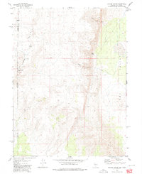
1980 Map of Parker Canyon
USGS Topo · Published 1980About this map
Dry Valley stretches along the eastern edge of this high-desert landscape on the border of California and Nevada, where the drainage patterns of Skedadle Creek and several canyons define the terrain. The map records a transition from high ridges to flat basin floors, marked by intermittent water sources like Telephone Spring and Pipe Spring. Evidence of human activity in this arid environment is sparse but significant for historians, including the identified Skedadle Dam (Site) and unnamed ruins located near the mouth of Parker Canyon. The presence of caves in Thomas Canyon suggests the geological complexity of these slopes, which are traversed primarily by a single Jeep Trail. This 1980 edition, based on earlier 1974-1975 fieldwork, preserves the exact state of the region's land use and survey boundaries before late-century changes.
Find a feature on this map
14 named features on this map. Tap any name to fly to it.
Don’t see what you’re looking for? This feature index may not catch every label — zoom into the map to look around manually.
Map Details
Editions of this 1980 Parker Canyon Map
This is the sole edition of this map. No revisions or reprints were ever made.
Other maps of this area

1886 · Honey Lake
USGS Topo · 1:250,000

1886 · Granite Range
USGS Topo · 1:250,000

1891 · Honey Lake
USGS Topo · 1:250,000

1893 · Honey Lake
USGS Topo · 1:250,000

1894 · Granite Range
USGS Topo · 1:250,000

1954 · Wendel
USGS Topo · 1:62,500

1954 · Doyle
USGS Topo · 1:62,500

1955 · Westwood
USGS Topo · 1:250,000

1955 · Lovelock
USGS Topo · 1:250,000

1958 · Westwood
USGS Topo · 1:250,000