1959 Map of Parker Dam
USGS Topo · Published 1978About this map
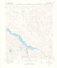
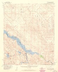
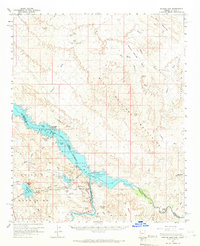
Havasu Lake dominates the center of this desert landscape, where the Colorado River was transformed by the engineering of the Parker Dam. This survey documents a critical junction of Western water infrastructure, showing the Colorado River Aqueduct intake at the Whitset Intake and its passage through the Whipple Mtn Tunnel. The map illustrates the complex management of this arid environment during the late 1950s, featuring the Havasu National Wildlife Refuge alongside active technical sites like the Parker Dam Powerplant and Gene Pumping Sta. Away from the water, the terrain is marked by remnants of resource extraction, such as the El Campo Mine and Manitowoc Mine in the northern reaches, while remote river access points like Black Meadow Landing and Larned Landing anchor the shoreline at the base of the Whipple Mountains.
Find a feature on this map
55 named features on this map. Tap any name to fly to it.
Don’t see what you’re looking for? This feature index may not catch every label — zoom into the map to look around manually.
Map Details
Editions of this 1959 Parker Dam Map
3 editions found
Other maps of this area

1903 · Needles
USGS Topo · 1:125,000

1904 · Needles Special
USGS Topo · 1:125,000

1911 · Parker
USGS Topo · 1:125,000

1923 · Signal
USGS Topo · 1:250,000

1927 · Buck Mountains
USGS Topo · 1:62,500

1929 · Buck Mountains
USGS Topo · 1:62,500

1942 · Signal
USGS Topo · 1:250,000

1943 · Giers Basin
USGS Topo · 1:62,500

1943 · Topock
USGS Topo · 1:62,500

1943 · Whipple Mts.
USGS Topo · 1:62,500