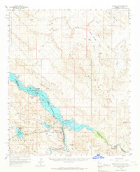
1959 Map of Parker Dam
USGS Topo · Published 1966About this map
The Colorado River and the massive Havasu Lake dominate this desert landscape, captured in the late 1950s after the engineering of the Parker Dam. The map details the complex water infrastructure of the era, including the Whitset Intake and the Gene Wash Reservoir, alongside the Havasu Lake National Wildlife Refuge. The terrain is defined by the Whipple Mountains and Aubrey Hills, where small-scale mining and ranching left their marks. Sites like the Manitowoc Mine and El Campo Mine speak to the region's mineral history, while the Kohen Ranch and remote landings like Black Meadow Landing indicate the sparse but persistent human presence along the river's edge. This survey provides a look at the desert before significant modern recreation development, focusing on water management and the rugged isolation of the Arizona-California border.
Find a feature on this map
59 named features on this map. Tap any name to fly to it.
Don’t see what you’re looking for? This feature index may not catch every label — zoom into the map to look around manually.
Map Details
Editions of this 1959 Parker Dam Map
3 editions found
Other maps of this area

1903 · Needles
USGS Topo · 1:125,000

1904 · Needles Special
USGS Topo · 1:125,000

1911 · Parker
USGS Topo · 1:125,000

1923 · Signal
USGS Topo · 1:250,000

1927 · Buck Mountains
USGS Topo · 1:62,500

1929 · Buck Mountains
USGS Topo · 1:62,500

1942 · Signal
USGS Topo · 1:250,000

1943 · Giers Basin
USGS Topo · 1:62,500

1943 · Topock
USGS Topo · 1:62,500

1943 · Whipple Mts.
USGS Topo · 1:62,500